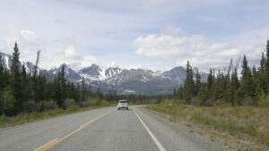
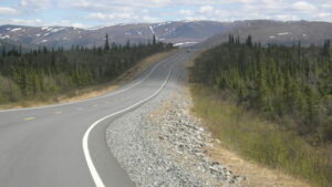
Alaska Highway – a spectacular scenic highway
The Yukon Territory has long been a dream destination for me. Getting a taste of the legendary Yukon Klondike gold rush and inmerse in the acclaimed majestic nature has always sounded very tempting.
For years I did follow – by email & books – the adventures of a friend on his hiking and canoeing trips. So, on a map, I’ve been there a hundred times already.
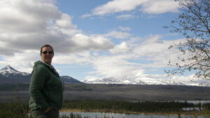
In May 2017 I was set for the real thing. Starting in Vancouver, we were going up the legendary Alaska Highway. A little over two weeks ALCAN and Yukon were on my itinerary. On some days we were “just burning up kilometers”, on others we hardly made any progress due to all the wildlife and photo stops.
We bathed in the Liard Hotsprings, saw the mighty wood buffaloes right on the highway, and almost got lost in the sign forest of Watson Lake. We saw grizzlies, a “cinnamon bear”, a lynxand learned that porcupines are avid climbers.
The Alaska Highway:
Useful information:
- runs from Mile Zero in Dawson Creek, British Columbia, to Delta Junction, Alaska
- length: about 2232 kilometers or 1,387 miles
- other names: Alaskan Highway, Alaska-Canadian Highway, ALCAN Highway
- construction period: March 09 to October 28, 1942 along the Northwest Staging Route airports. Sub-routes include BC Highway 97, Yukon Highway 1 and Alaska Route 2
- cities along route: Dawson Creek - Fort St.John - Fort Nelson - Watson Lake - Whitehorse - Haines Junction - Tok - Delta Junction
Important
Mobile phone reception in rural areas is sometimes very patchy with wide gaps in reception.
Petrol stations/service points can be found every 200 - 250 kilometres. Recommendation: always fill up if possible Reserve accommodations/RV Parks/ Campgrounds in advance during summer season.
- Dawson Creek: Mile O (Zero) Monument, Visitor Center with NAR Railway Station Museum
- Taylor: Peace River Crossing
- Fort Nelson: Fort Nelson Heritage Museum, Visitor Center
- Summit Pass & Summit Lake: Highest point on the Alaska Highway, Stone Mountain Provincial Park
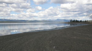
- Muncho Lake: 12 kilometers long and up to 300 meters deep, Muncho Lake Lodge & Camping
- Liard River Hot Springs Provincial Park, wood bison herds along highway
- Smith River Falls
- Watson Lake: Sign Post Forest with signs from around the world, Staging Route Airport, Airport Lodge (historic Staging Route Hotel), Northern Lights Centre
- Rancheria Falls
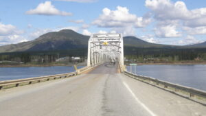
- Teslin: Teslin Tlingit Heritage Centre, Nisutlin Bay Bridge & George Johnston Museum
- Whitehorse: Kwanlin Dün Cultural Centre, Swatka Lake & the Fishladder, Miles Canyon & Bridge, S.S. Klondike National Historic Site, Yukon Beringia Interpretive Centre, Yukon Transportation Museum
- Haines Junction: Visitor Centre, scenic flights over Kluane National Park, Lake Katleen, Kluane Lake
- Sheep Mountain
- Delta Junction: Endpoint of the Alaska Highway, Bison herds
We saw a lot of black bears along the Alaska Highway. We were particularly happy to also see colour variants such as the russet cinnamon bear.
The chances of seeing moose, grizzlies or even a bobcat or lynx are pretty high in the north. Of course, the "at the right time in the right place" principle always applies.
Highlights along the Liard Highway section were the North American wood bison herds along - or even right in the middle of - the Alaska Highway near Liard Hot Springs and spotting caribous near Summit Pass/Lake.
In the Yukon & Alaska, porcupines and eagles are common sighted wildlife and we learned that pocupines are avid climbers.
The Alaska Highway is open to traffic all year round and is paved throughout. From Dawson Creek to Fairbanks, the route traverses different climate zones. Weather can change quite rapidly during all seasons.
- most tourists/travellers travel the Alaska Highway between May & September
- at high altitudes, such as the Summit Pass, snow showers & hail can also happen during summer season
- ice can cover the lakes - Muncho Lake to Kluane Lake - well into May
- in the north it usually doesn't "turn green" until the end of May and the first autumn colors can sometimes be seen in the north as early as August
- first frost can occur in the Yukon and Alaska from mid-September
- some attractions & tours open around Memorial Day weekend and close after Labor Day
- May & June are usually drier than July, but come with more insects than late summer
- Winters are very cold and snowy. The Alaska Highway is cleared regularly, but due to long distances clearing take some time.
Important in winter: a winter-proof sleeping bag, insulating blankets and extra warm clothing as well as provisions for 3-4 days. Spare parts/wheels and repair kits/tools should travel with you in the heated interior so that frozen spare parts/tools do not unnecessarily prolong work in the cold.
How to get to the Alaska Highway
We flew from Frankfurt am Main to Vancouver, also Edmonton & Fairbanks are the major international airports closest to start and end points. However, Anchorage and Calgary are also great for driving the Alaska Highway with additional highlights in Canada & Alaska.
All year round you can fly with Lufthansa and Air Canada scheduled flights, during the summer season the tourist airlines Condor and from 2022 also Eurowings Discover will fly to Canada & Alaska.
Rental car or RV/Campervan?
This is indeed a very individual choice. For me personally it is a question of the travel region, travel route, travel season and what I expect from my travels. Keep in mind that you have to plan one night before picking up an RV or campervan. Arrival and pick-up on the same day is not possible. Also, in Canada & Alaska – except for the Yukon & the NWTs – you always have to stay overnight in a campground or RV park. Overnight parking in public places/on public roads is mostly a punishable offense. You have to reserve popular RV Parks & campgrounds in advance, because these are usually booked quickly for the summer season – which nowadays runs from mid-May to the end of September.
That’s why I usually travel with a rental car in North America. Small accommodations and wonderful hosts add extra tips, stories and often also new friends to my itinerary.
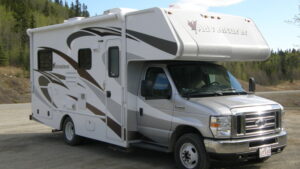
In May 2017, we drove the Alaska Highway in a midsize RV. We were traveling in a C24 motorhome from Fraserway. After a quick but thourough briefing, we quickly felt comfortable with our RV and drove off to new adventures.
Our routing for the next ten days:
- Clearwater, BC to Prince George
- Prince George to Dawson Creek
- Dawson Creek to Fort Nelson
- Fort Nelson to Watson Lake
- Watson Lake to Whitehorse
- Whitehorse to Haines Junction
- Carcross & Goodbye
The best time to drive the Alaska Highway?
British Columbia and the Yukon are year-round destinations. In summer, wild animals, panoramic routes, hiking and canoe tours are the most sought after attractions. The winter comes with magical northern lights, snowshoeing, skiing and sledding tours.